


17 Apr Fairview Peak Earthquake Fault
At 3:08 a.m. on December 16, 1954 an earthquake measuring 7.3 in magnitude was centered near Fairview Peak, a few miles south of Highway 50 east of Fallon. This major quake was widely felt in several western states. Slightly further east and just north of Highway 50, in Dixie Valley, a second earthquake of comparable size jolted the area on the same day.
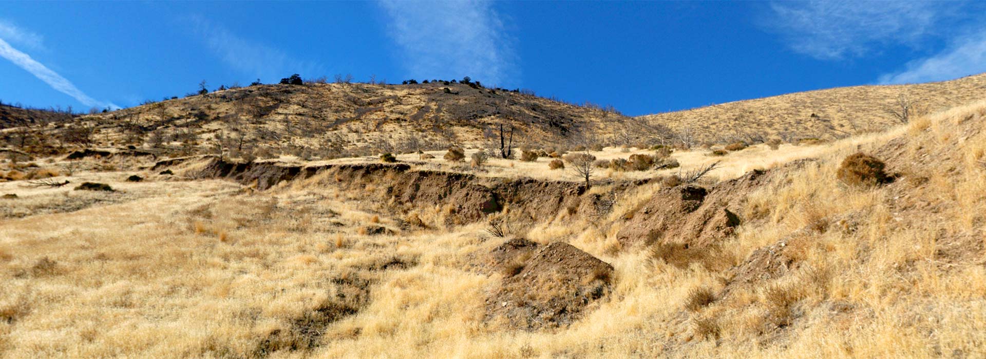
Residents of the remote Dixie Valley claimed that the valley echoed with loud booms starting moments before the quake was first felt and lasting until long after it stopped. More than 10 miles of faulting were exposed at Fairview Peak and in the Stillwater Range to the northwest. In seconds, the mountains lifted up an average of six feet relative to the valleys below.
These dramatic earthquake scarps, or exposed fault lines, may be noted in this VR tour in several places. Click the red hotspots to explore the earthquake fault area from five different positions. The blue information hotspots contain text written by David VonSeggern, Emeritus Seismic Network Manager of the Nevada Seismological Laboratory at the University of Nevada, Reno.
Touch here for the HMD version.
Click here to see the location in Google Maps.
Andrew Bringard
Posted at 19:18h, 19 OctoberDriving on Hwy 50 for the first time on my way to CA, I passed the sign that said earthquake fault 6 miles. I had to turn around and go check it out. So glad I did. Once you get there you can see it. And if you are reading this then you now know what to look for after seeing the 360 view above. There is a path you can walk along the top of it to get a better feel for it. Wish I would have seen this site before I went also. I would have explored more.
Rick Saunders
Posted at 02:05h, 27 JuneI visited this famous site in 1990 while deployed to NAS Fallon, NV. I was surprised to see clear evidence of the ancient thrust and slip faults on the surface. In some surface areas, vertical rips of the soil and rock measured several feet in height and ran in a straight line for hundreds of yards. I recommend the site for day-field trips to explore geophysics and obtain images of the earth undergoing constant changes.
Amanda Green
Posted at 14:37h, 13 MayNothing told us how far this was from Fallon. It’s about 30 miles east of Fallon, and then 6 miles on a dirt road.
Brad Smith
Posted at 09:49h, 08 SeptemberWonderful presentation! I wish I had seen it before visiting the site. I will certainly look at it again before my next visit.